The brief for this project was to create a 3D scene in OpenGL to show off what you could do. We weren't allowed to use any external libraries for anything visual. We had the option to recreate a scene from a game or movie but I chose to create something from scratch. The scene I ended up building was 'The Museum'. Making a museum made it extremely easy to demonstrate any technique I wanted: want to show off animated textures? Make it an exhibit! Simple.
With a long list of things I wanted to demonstrate I decided to design the museum in a modular fashion. Each room would house an exhibit or collection of exhibits demonstrating related techniques. Then I could just plug the rooms next to each other and hey-presto it's the most surreal museum you've ever visited.
With a long list of things I wanted to demonstrate I decided to design the museum in a modular fashion. Each room would house an exhibit or collection of exhibits demonstrating related techniques. Then I could just plug the rooms next to each other and hey-presto it's the most surreal museum you've ever visited.
The Entrance Hall - Text, HUD text and models
The very first thing that the player sees when they run the program is the instructions screen shown below (ignore the terrible frame rate, my current laptop can't really handle anything 3D).
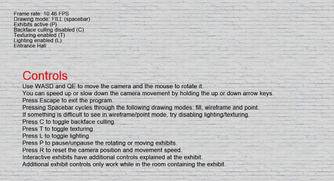
This text isn't a pre-baked texture (indeed the text in the top-left is HUD text which continually updates); it's rendered in real time. To do this I used a program called BMFont which generates a texture with a set of characters rendered in a certain font and an accompanying text file which describes the location and size on the texture of each character. By parsing the text file it's then pretty straightforward to create a plane with texture coordinates to match any given character. Since the text file also includes information on how far to advance the cursor after each character, a series of planes (one per character) can be created to represent a string of text.
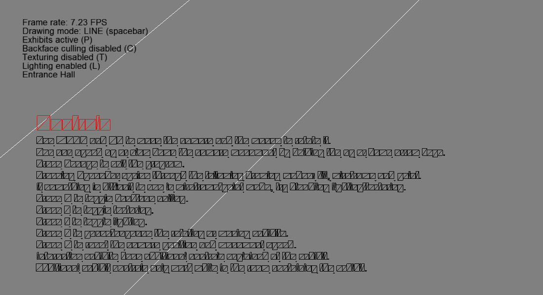
The controls screen in wireframe mode. Note that the HUD text ignores the drawing mode and texturing toggle.
Having got accustomed to the controls, the player turns around and is confronted with...
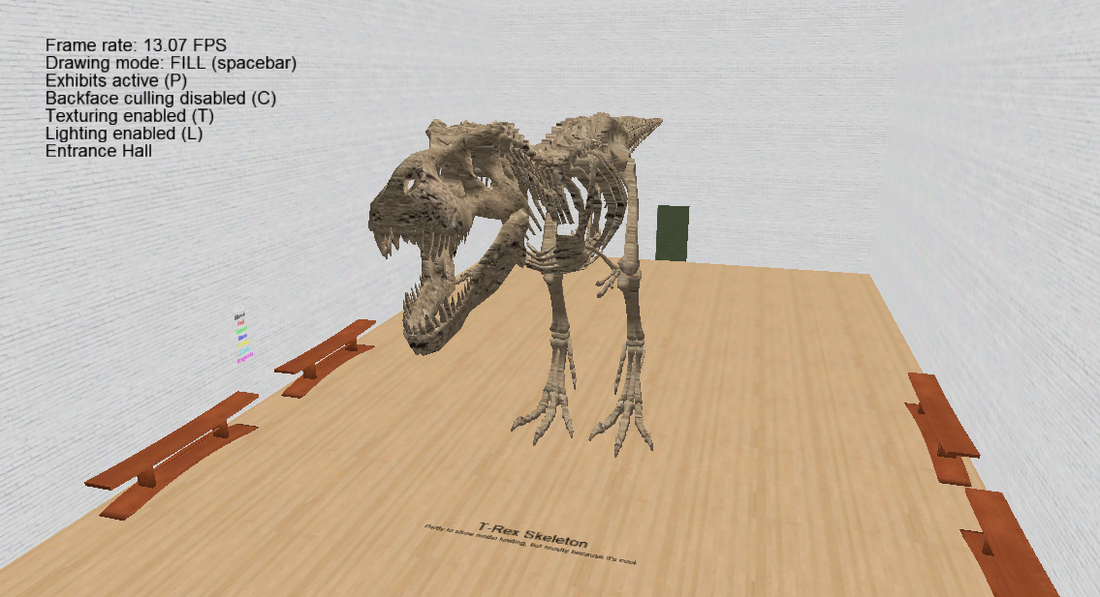
What museum would be complete without a T-Rex skeleton?
Both the T-Rex and bench are royalty-free .obj models sourced online and loaded in at startup. This skeleton actually causes the majority of startup loading time due to the complexity of the model. The .obj files are read in and processed line by line to extract the information about the vertices, texture coordinates, normals and faces. This information is then stored in an instance of the Model class which can then be rendered repeatedly with any position, orientation and scale.
As a side note, the T-Rex model included texture coordinates but no texture. I had a dirt texture for some procedural terrain (more on that later) so I stuck that on the model and it looked suitably fossilised.
Note that the HUD text stays in the same position on the screen regardless of the orientation and position of the camera. This was done by transforming the text to match the position and rotation of the camera, then scaling the text right down and translating it by a small amount along the camera's local z axis to get the text past the near clipping plane and into the viewing frustum. This also means that the HUD text is guaranteed to be closest on the z axis and therefore rendered in front of everything else. Translating in the local x and y positions the text on the screen.
The Garden - Boxing up the sky and connecting modular rooms
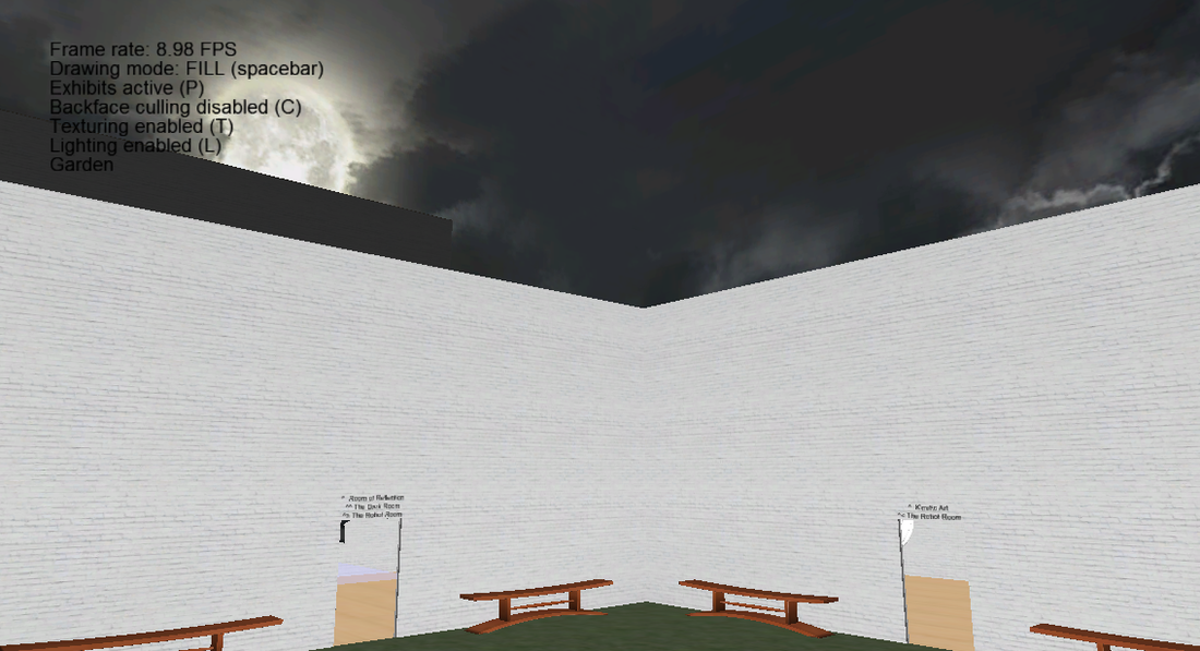
The garden exists partly as a central navigation hub but mostly as an excuse to show the skybox without clipping through the ceiling. The skybox is a small inward-facing cube rendered at the location of the camera with depth-testing disabled. This means it isn't added to the depth buffer and therefore nothing knows it exists. Anything rendered afterwards will then be drawn in front of it, even though the skybox is probably closer to the camera.
Although it has no ceiling, the garden is actually just another instance of the Room class, the same as any other. Each instance of the Room class has a width, height and depth; a position (the x and z parts are the centre of the room, the y is the height of the floor); a bit-field for whether the room has a ceiling, a floor and north, east, south or west walls; and another bit-field for whether the north, east, south or west walls have doors in them. The doors are always the same size and are always positioned in the middle of the wall. So to connect the garden and the entrance hall for example, I simply had to say that the entrance hall had a north wall with a door and the garden had a south wall with a door, then make sure they had the same x and y coordinates (even though the entrance hall is taller) and position them on the z axis such that they just meet (which is easy since we can get their dimensions).
Although it has no ceiling, the garden is actually just another instance of the Room class, the same as any other. Each instance of the Room class has a width, height and depth; a position (the x and z parts are the centre of the room, the y is the height of the floor); a bit-field for whether the room has a ceiling, a floor and north, east, south or west walls; and another bit-field for whether the north, east, south or west walls have doors in them. The doors are always the same size and are always positioned in the middle of the wall. So to connect the garden and the entrance hall for example, I simply had to say that the entrance hall had a north wall with a door and the garden had a south wall with a door, then make sure they had the same x and y coordinates (even though the entrance hall is taller) and position them on the z axis such that they just meet (which is easy since we can get their dimensions).
The Procedural Room - Generating geometry,
Sierpinski tetrahedrons and infinite terrain
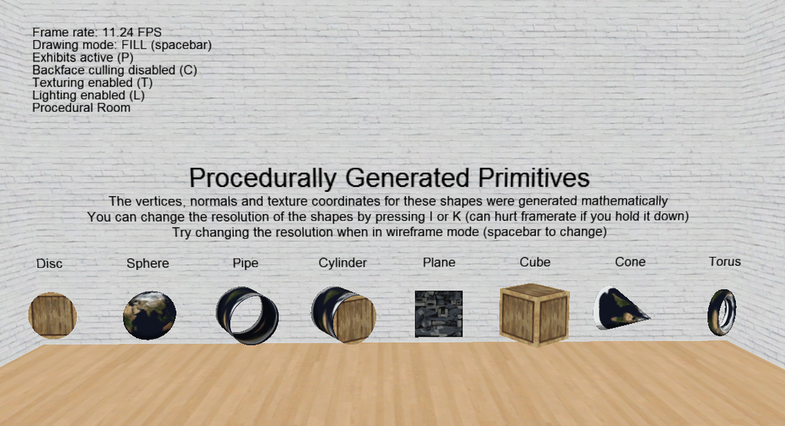
As part of the course we learnt how to create some basic geometric shapes such as a disc or cube, as well as more complex shapes such as a pipe or sphere. I ended up doing 8: disc, sphere, pipe, cylinder, plane, cube, cone and torus. I made it so that you can change the resolution of these shapes during run time. Below you can see the minimal state of each shape (the lowest possible number of polygons to create each shape) as well as a more representative resolution.
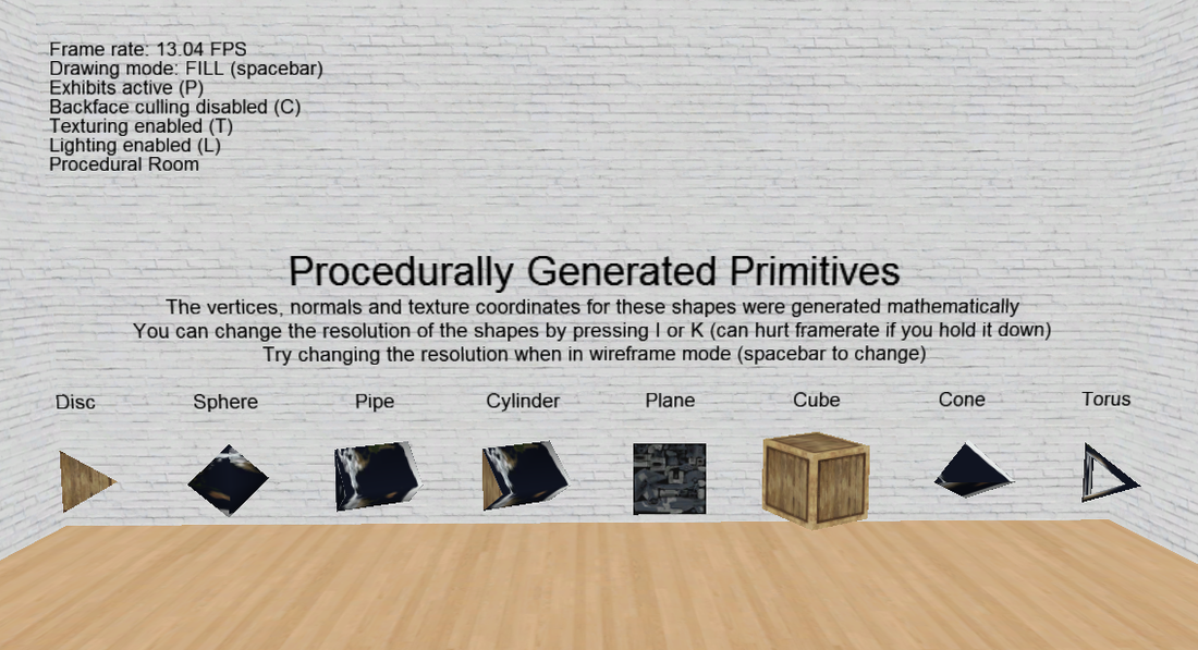
Everything in the procedural room is created and defined by mathematical equations or algorithms. As such they are all modifiable at run time.
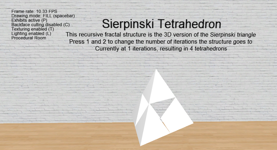
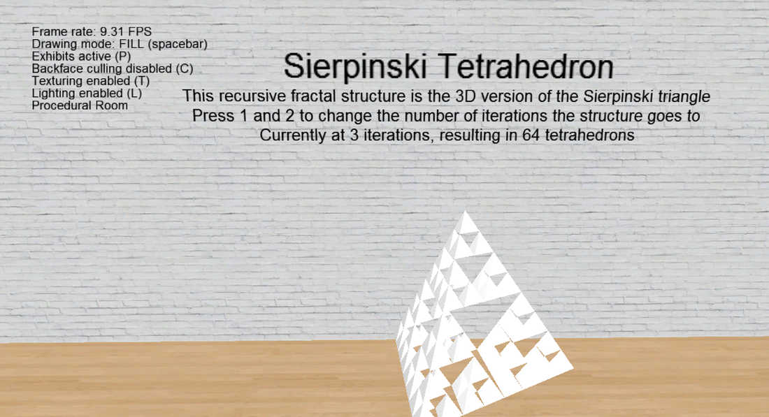
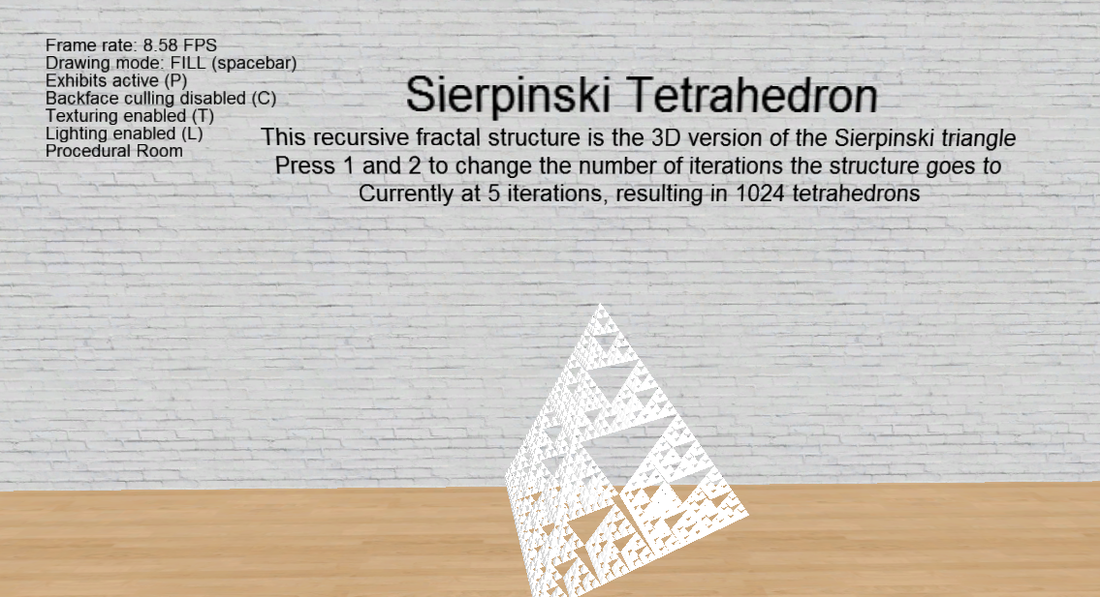
A Sierpinski triangle is a fractal shape which uses equilateral triangles to fill an equilateral triangle. Since this is a 3D scene and a tetrahedron is the 3D equivalent of an equilateral triangle, I created a Sierpinski tetrahedron instead. You can change the number of iterations the recursive algorithm uses at run time.
I wanted to do some kind of terrain generation so I started mucking around with a mesh of evenly-spaced vertices. What I ended up doing was generating random y coordinates for all of the points along one edge, then moving those heights along the mesh at a certain rate (generating new heights along the leading edge). This gave the illusion of infinitely scrolling terrain. I made it so that the number of vertices per edge and the rate the terrain updated were changeable at run time. I also textured the mesh with a tileable dirt texture and made the texture coordinates move across the mesh with the y coordinates.
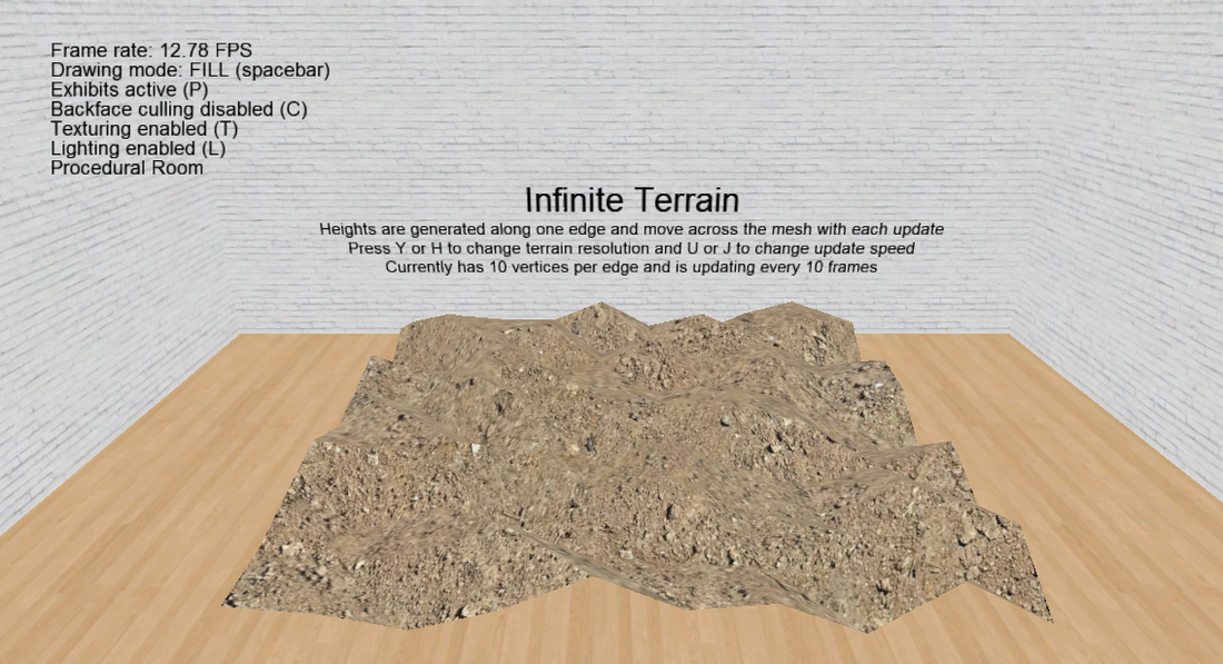
The difficulty came in lighting the thing, i.e. calculating normals for all the faces. For my first attempt I just ran along the leading edge calculating a normal per triangle (using two edges as vectors and finding their cross product) and having those normals move across the mesh as well. Although this kind of worked it was very clearly not correct.
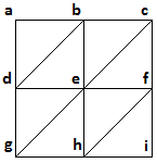
After speaking to my lecturer about it he recommended I try implementing shared normals. Looking at the set of vertices on the right, the normal for vertex e would be the average of the normals for all of the surrounding triangles which feature that vertex. Obviously the shared normal for vertex e will give the best result as it takes into account the most surrounding triangles.
Imagine edge g-h-i as being the bottom, leading edge of the terrain (where new y coordinates are created). I calculate and store the shared normals for vertices e and h because those take into account as many surrounding triangles as possible. By starting with edge a-d-g on the leftmost edge of the terrain and repeating this process until edge c-f-i is on the rightmost edge of the terrain, I calculate shared normals for every vertex along the leading edge and along the row of vertices above it (when on the leftmost or rightmost edges of the terrain, the normals for d and g or f and i respectively are stored). The normals along g-h-i are stored because there is no row below it and therefore no more triangles to take into account. Once the terrain updates, what was g-h-i before is now d-e-f and a new set of heights (and therefore a more complete average) is possible, hence the normals for d-e-f are stored. The normals for a-b-c are never stored because they are simply the previous update's d-e-f, so have already taken into account as many triangles as possible.
At this point the terrain was scrolling infinitely and lighting properly. But due to the way the terrain was generated (just randomised heights) it was very erratic and looked less and less natural as the number of vertices was increased. I thought through how I was going to fix this problem, but didn't have time to implement it. My plan was to have a maximum and minimum height a vertex's y coordinate could be. To calculate a new y coordinate you add a random amount onto the previous y coordinate. The random amount is based on a weighted range covering both positive and negative values. The closer the previous height was to the maximum height, the more the range would be weighted in the negative (and vice versa), thereby forcing the height to remain within the limits. Since each height was based on the previous height, the difference wouldn't be too great and the terrain overall would be smoother. As the number of vertices of the scroll speed increased, the possible random range would decrease as each vertex is now effectively closer to each other vertex. This doesn't take into account the differences in height between adjacent vertices in a row, only between rows, but it was just the start of thinking through the problem.
Read Part 2.
 RSS Feed
